Task high-resolution imagery
The NUVIEW Platform allows you to order satellite and LiDAR imagery directly from within a site or from the Search section. The Advanced Order screen gives you full control over product selection, collection timing, and order details.
Accessing the Order Screen
- From a site: click the Order data button in the upper area of the site panel.
- From Search: after finding imagery, click Order data in the top-right corner of the interface.
Both paths open the Advanced Order screen (Search › Advanced Order).
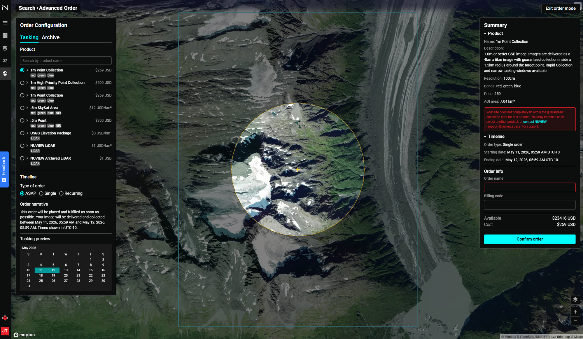
Order Configuration
Tasking vs. Archive
The Order Configuration panel has two tabs:
- Tasking — Task a new satellite collection over your AOI. The satellite will be directed to collect imagery within your specified window.
- Archive — Order previously collected imagery that already exists in the catalog.
Available Products
| Product | Bands | Notes |
|---|---|---|
| 1m Point Collection | Red, Green, Blue | 1.0m or better GSD; 4km × 6km image; 1.5km guaranteed radius around target point |
| 1m High Priority Point Collection | Red, Green, Blue | Elevated priority in satellite queue for faster or more reliable collection |
| .5m SkySat Area | Red, Green, Blue, NIR | 0.5m resolution area collection |
| .5m Point | Red, Green, Blue, NIR | 0.5m resolution point collection; 2.5km guaranteed radius |
| USGS Elevation Package | LiDAR | Publicly available USGS LiDAR elevation data |
| NUVIEW LiDAR | LiDAR | NUVIEW-collected LiDAR point cloud data |
| NUVIEW Archived LiDAR | LiDAR | Previously collected NUVIEW LiDAR archive |
Use the Search by product name field to quickly find a specific product.
Timeline — Type of Order
Select how the order should be scheduled:
- ASAP — The order is placed and fulfilled as soon as possible. Your image will be collected within the next available window (typically within 24 hours for the start of the collection window).
- Single — Schedule collection for a specific date.
- Recurring — Set up a repeating order on a defined cadence.
The Order narrative below the selection describes exactly when your image will be collected based on the current settings.
The Tasking preview calendar highlights the collection window so you can confirm the dates before ordering.
Order Summary
The right Summary panel updates in real time as you configure your order:
- Product name and description — Full details of the selected product including resolution, band configuration, and delivery specifications.
- Resolution — Ground sample distance (e.g., 100cm for 1m products).
- Bands — Spectral bands included (e.g., red, green, blue, NIR).
- Price — Unit cost for the selected product.
- AOI area — The calculated area of your site in km².
- Timeline — Order type, starting date, and ending date in your local timezone.
- Available balance — Your current credit balance.
- Cost — Total cost for this order.
Note: If your site does not fit within the guaranteed collection radius for the selected product, a warning will appear. You can continue as-is, select a different product, or contact support@nuview.space for assistance.
Order Info
Before confirming, enter:
- Order name — A descriptive name to identify this order in your Orders list.
- Billing code — Optional code for internal billing or cost-center tracking.
Click Confirm order to submit. You'll receive an email notification when the imagery has been collected and is ready in your platform.
After Ordering
Once your imagery is collected and processed, it will appear in your site's Timeline with a private imagery indicator. See Download raw imagery to export the data for use in external GIS tools.